Keywords
Susceptibility
AHP
GIS
Mapping
Constantine
How to Cite
Abstract
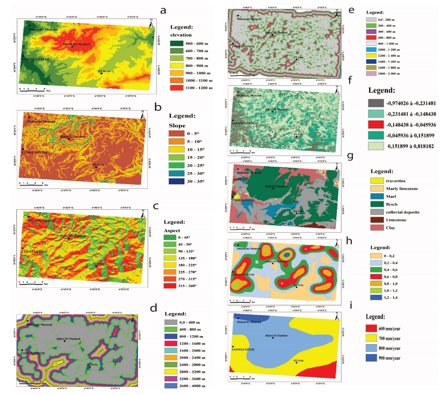
Landslides constitutes one of the main geological dangers to human being. Proper analysis and suitable modeling of these dangers may reduce accident risks. In this study, we used remote sensing techniques and GIS tools to establish landslide susceptibility map of the East of Constantine. To evaluate the landslide risks in the study area, analytical hierarchy process (AHP) method and Weighted Linear Combination (WLC) were used. In this method, we performed quantification of the factors on a priority basis by pair-wise comparison of the factors. The local data includes slope, slope aspect, elevation, distance from drainage, lithology, distance from faults, precipitation, and Normalized Difference Vegetation Index (NDVI) and springs density. The landslide susceptibility index (LSI) was calculated using the WLC technique based on the assigned weight and rating by AHP method. The results were verified using actual landslide locations (43 location points) where the accuracy rate 61% of predict values and 58 % of success values. The validation results with that indicated suitable agreement between the susceptibility map and the existing data on landslide locations.
References
Bougdal R., Belhai D., Antoine P. (2007) Géologie détaillée de la ville de Constantine et ses alentours: une donnée de base pour l’étude des glissements de terrain. Bull Serv Géol de l’Algérie, 18(2):161–187.
Pincent B., Bougdal R., Panet M., Bentabet A. (2008). Le pont Sidi Rached à Constantine, Algérie : une culée dans un grand glissement de terrain. Bull Serv Ge´ol de l’Algérie, 19(3):197–215.
Machane, D., Bouhadad, Y., Cheikhlounis, G., Chatelain, J., Oubaiche, E., Abbes, K., Guillier, B. and Bensalem, R. (2008). Examples of geomorphologic and geological hazards in Algeria. Natural Hazards, 45(2), pp.295-308.
Guemache, M., Chatelain, J., Machane, D., Benahmed, S. and Djadia, L. (2011). Failure of landslide stabilization measures: The Sidi Rached viaduct case (Constantine, Algeria). Journal of African Earth Sciences, 59(4-5), pp.349-358.
Manchar, N., Benabbas, C., Kacimi, M., Mimoun, A. and Bouaicha, F., (2012). Risque de glissements et aménagement: l'exemple d'un remblai autoroutier à Taffrent (NE de Constantine, Algérie nord orientale).1er Congrès international de génie civil et d'hydraulique, Univ. 8 Mai 1945, Guelma, Algérie.
Bougdal, R., Larriere, A., Pincent, B., Panet, M. and Bentabet, A. (2013). Les glissements de terrain du quartier Bélouizdad, Constantine, Algérie. Bulletin of Engineering Geology and the Environment, 72(2), pp.189-202.
Bourenane, H., Bouhadad, Y., Guettouche, M. and Braham, M. (2014). GIS-based landslide susceptibility zonation using bivariate statistical and expert approaches in the city of Constantine (Northeast Algeria). Bulletin of Engineering Geology and the Environment, 74(2), pp.337-355.
Bourenane, H., Guettouche, M., Bouhadad, Y. and Braham, M. (2016). Landslide hazard mapping in the Constantine city, Northeast Algeria using frequency ratio, weighting factor, logistic regression, weights of evidence, and analytical hierarchy process methods. Arabian Journal of Geosciences, 9(2).
Varnes, D.J. 1984. Landslide Hazard Zonation: a Review of principles and practice. Natural Hazards. N°. 3. 1st ed. UNESCO, Paris, France, 63p.
Dai, F., Lee, C. and Ngai, Y. (2002). Landslide risk assessment and management: an overview. Engineering Geology, 64(1), pp.65-87.
Guzzetti, F., Reichenbach, P., Cardinali, M., Galli, M. and Ardizzone, F. (2005). Probabilistic landslide hazard assessment at the basin scale. Geomorphology, 72(1-4), pp.272-299.
Sharma, V. K., 2006. Landslide hazard zonation: an overview of emerging techniques. Journal of Engineering Geology, XXXIII, 73-80.
Guzzetti, F., Carrara, A., Cardinali, M., & Reichenbach, P. 1999. Landslide hazard evaluation: a review of current techniques and their application in a multi scale study, Central Italy. Journal of Geomorphology, 31, 181-216. Elsevier, London.
Carrara, A., Cardinali, M., Guzzetti, F., & Reichenbach, P. 1995. GIS-Based techniques for mapping landslide hazard in Geographical Information System in Assessing Natural Hazards. Dordrecht: Academic
Saha, A. K., Gupta, R. P., et Arora, M. K., 2002. GIS based landslide hazard zonation in the Bhagirathi (Ganga) Valley, Himalayas. International Journal of Remote Sensing, 23, 357-369pp.
Lee S. (2005). Application of logistic regression model and its validation for landslide susceptibility mapping using GIS and remote sensing data. Int J Remote Sens 7:1477-1491.
Van Westen, C. J., Castellanos Abella, E., et Sekhar, L. K., 2008. Spatial data for landslide susceptibility, hazards and vulnerability assessment: an overview. Engineering Geology, 102, 112-131.
Soeters, R., & Westen, C. J. 1996. Slope instability recognition, analysis and zonation. In A. K. Turner and R. L. Schuster (Eds), Landslides: Investigation and Mitigation. Transportation Research Board Special Report 249, 129-177.
Rowbotham D., Dudycha D. (1998). GIS modelling of slope stability in Phewa Tal watershed, Nepal. Geophys J Roy Astron Soc 26:151-170.
Lee S, Pradhan B. (2006). Probabilistic landslide hazard and risk mapping on Penang Island, Malaysia. J Earth Syst Sci 115:661-672.
Muthu, K., Petrou, M., Tarantino, C., and Blonda, P. (2008). Landslide Possibility Mapping Using Fuzzy Approaches. IEEE Transactions on Geoscience and Remote Sensing, 46(4): 1253-1265.
Pradhan, B. (2010). Remote Sensing and GIS-based landslide hazard analysis and cross validation using multivariate logistic regression model on three test areas in Malaysia. Advances in Space Research, 45, 1244-1256.
Pradhan, B. and Lee, S. (2010). Delineation of landslide hazard areas using frequency ratio, logistic regression and artificial neural network model at Penang Island Malaysia. Environ Earth Sci (2010) 60:1037-1054. DOI: 10.1007/s 12665-009-0245-8.
Ma, F., Wang, J. Yuan, R, Zhao, H, Guo, J. (2013). Application of analytical hierarchy process and least square method for landslide susceptibility assessment along Zhong-Wu natural gas pipelines. China Landslides Doi;, Doi: 10.1007/s 10346-013-0402-8.
Kavzoglu, T., Sahin, E., and Colkensen I. (2013). Landslide susceptibility mapping using GIS based multi-criteria decision analysis, support vector machines and logistic regression. Landslides, doi:Doi: 10.1007/s 10346-013-0391-7.
Guiraud, R. (1973). Evolution post-triasique de l’avant pays de la chaîne alpine en Algérie. D’après l’étude du bassin du Hodna et des régions voisines. Thèse de Doctorat Es Science, stratigraphie, Nice, 270pp.
Coiffait, P.-E., and VILA J M., 1977: Carte géologique de l'Algérie aux 1/50.000 feuilles d'El Aria avec notice explicative.
Coiffait, P.-E., 1992. Un bassin post-nappe dans son cadre structural: l'exemple du bassin de Constantine (Algérie nord-orientale). Th. Doct. Etat Sci. Nat., Nancy, 1: 405.
Vila, J.-M., 1980. La chaîne alpine d'Algérie orientale et des confins algéro-tunisiens. Thèse Sc. Univ. Paris VI, 3 vol, 663 p., 199 fig., 40 pl., 7 pl.h.t.
Lahonder, J., C, 1987. Les séries ultratelliennes d’Algérie Nord-Orientale et les formations environnantes dans leur cadre structural, Paul Sabatier, Toulouse, France, 242 pp.
Raoult, J.F., (1974). Géologie du centre de la chaîne numidique (nord du constantinois, Algérie). , Paris, France, 156 pp.
Durand-Delga M(1969) Essai sur la structure du NE de la Berberie. Bull Serv Carte geol Algérie 39:89–181.
Crozier, M. J. (1986). Landslides: causes, consequences and environment, Croom Helm, London.
Coromina, J. (2000). Landslides and climate. Keynote lecture, in: Proceeding of the 8th International Symposium on Landslides, Balkema, Cardiff, 4, 1-33.
Tucker, C.J., Dregne, H.E. and Newcomb, W.W., 1991. Expansion and contraction of the Sahara Desert. Science, 253, pp.299-301.
Saaty, T.L. 1980. The Analytical Hierarchy Process. McGraw Hill, NY, 350p.
Malczewski, J. 1999. GIS and Multi-Criteria Decision Analysis.1st ed. Jhon Wiley and Sons, NY, 392p.
Saaty, T. L. 1977. A scaling method for priorities in hierarchical structures. Journal of mathematical psychology, 15(3), 234-281.
Voogd, H. (1983). Multicriteria Evaluation for Urban and regional Planning. 1st ed. Pion Ltd., London, 367p.
Zweig MH, Campbell G (1993) Receiver-operating characteristics (ROC) plots. Clin Chem 39: 561–577.
Hanley JA, McNeil BJ (1983). A method of comparing the areas under receiver operating characteristic curves derived from the same cases. Radiology 148:839–843.
Lee S. (2005). Application of logistic regression model and its validation for landslide susceptibility mapping using GIS and remote sensing data. Int J Remote Sens 7:1477-1491.

This work is licensed under a Creative Commons Attribution-NonCommercial-NoDerivatives 4.0 International License.